Sudan: SAS on Heglig & Abyei

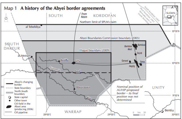
If you're looking for info on Sudan, there's few better resources than the Small Arms Survey's Sudan Human Security Baseline Assessment reports. They have a new one on the conflict over Heglig, as well as a wider look at fighting in Abyei and the above map [PDF]. From the first one:
Most of the fighting has focused on Heglig, Sudan’s largest oil field, which produced 55,000 barrels a day; the income derived from this oil had become crucial to Sudan following South Sudan’s decision in January to suspend its oil production, depriving Sudan of fees from the oil’s transit through its territory. By many reckonings, Heglig is north of the 1956 historical border that is supposed to dictate the frontier between the two states. But many Southerners have long considered it part of the South. Heglig, which is known as Thou (or Panthou) in Dinka, was one of the territories depopulated by militias during the second civil war, when Sudan used paramilitary Popular Defence Forces (PDF) to clear southern residents from areas around oil-producing sites. For many Dinka at the border, accepting Sudan’s possession of these territories is tantamount to accepting the ethnic clearings of the 80s and 90s.
. . .
The prospects for negotiation are poor. SAF has said the Heglig attack nullifies Sudanese commitments made in Addis Ababa, and that there will be no further talks. Bashir has been even more bellicose, declaring that the current conflict will end either ‘in Juba or Khartoum’, i.e. with the destruction of one of the parties. Such statements are designed for internal consumption in Sudan, and do not reflect Sudan’s actual bargaining position. The fighting may in fact ease with the coming of the rainy season. The recent battles may be simply attempts by both sides to carve out positions on the ground before rains begin.
